 http://www.wired.com/magazine/2010/02/ff_algorithm/all/1
Friday, February 26, 2010
Tuesday, February 23, 2010
5th International Workshop on 3D Geo Information, 3-4 November 2010, Berlin
"The 5th International 3D GeoInfo Conference 2010 aims at bringing together international state-of-the-art research and facilitating the dialogue on emerging topics in the field of 3D geo-information. In recent years, research has focused on improving 3D data acquisition technology through remote sensing, photogrammetry, laser altimetry techniques (LiDAR), and visualization technology (3D CAD and Virtual Reality (VR) system) for 3D urban environments...."
source and more information: http://www.igg.tu-berlin.de/3dgeoinfo/
call for papers: http://www.igg.tu-berlin.de/3dgeoinfo/cfp.pdf
source and more information: http://www.igg.tu-berlin.de/3dgeoinfo/
call for papers: http://www.igg.tu-berlin.de/3dgeoinfo/cfp.pdf
Monday, February 22, 2010
iPhone Camera for a 3D Project
I like PhotoModeler, you can create in this program excellent 3D model with texture!
You can use only iPhone with fixed lens as a survey instrument, sounds great... :)
Here is a good example:
".....The photos were loaded into PhotoModeler Scanner, marked for key points and oriented (PhotoModeler figures out where the iPhone was at the time of each exposure). Then the DSM (dense surface modeling) algorithm was run on the photos to produce dense point clouds - like a laser scan would do but all correctly tied together...."
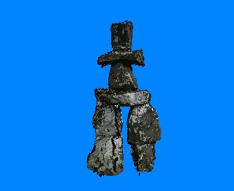
Source and more information: http://www.photomodeler.com/applications/other/iPhone_Inukshuk.htm
Thursday, February 18, 2010
LizardTech - LiDAR File Compression
“LiDAR Compressor compresses your LiDAR data to the industry standard MrSID format, trusted as a raster format by geospatial professionals since 1992 and supported in virtually all GIS applications. With the release of LiDAR Compressor LizardTech unveils a new and improved version of the format, MrSID Generation 4 (MG4). It's still LizardTech and it's still MrSID, so you know you're using the highest quality file format with the most advanced compression technology available. MG4 enables you to view and access your LiDAR data faster.”
LiDAR Compressor costs: 2995$
Source and more information: http://www.lizardtech.com/products/lidar/
Sunday, February 14, 2010
Airborne Laser Testbed Successful in Lethal Intercept Experiment
"The Missile Defense Agency demonstrated the potential use of directed energy to defend against ballistic missiles when the Airborne Laser Testbed (ALTB) successfully destroyed a boosting ballistic missile. The experiment, conducted at Point Mugu Naval Air Warfare Center-Weapons Division Sea Range off the central California coast, serves as a proof-of-concept demonstration for directed energy technology. The ALTB is a pathfinder for the nation’s directed energy program and its potential application for missile defense technology....."

source and more information: http://www.mda.mil/news/10news0002.html
source and more information: http://www.mda.mil/news/10news0002.html
Thursday, February 11, 2010
News: DAVID Laserscanner v2.5.1
New version of low cost DAVID 3D scanner is arrived! It is only 400$, good solution to scan small objects!
Popular low-cost 3D scanner: http://www.david-laserscanner.com/laserscanner.com/

If you want to make alone a 3D scanner, here is a good example (homemade laser scanners): http://www.muellerr.ch/engineering/overview.html
Augmented reality, a vision of the future
http://vimeo.com/8569187
Interesting to see here, that augmented reality is used for advertising (on a massive scale), and only a little bit of useful information.
But this is only a utopia. Maybe it will really be used to gather and visualize information about ancient buildings, and old churches in town..
Point Clouds from Imagery
"Get ready to generate high-resolution terrain information from your stereo imagery like never before. LPS eATE is a new technology for automatic terrain extraction, providing an unparalleled environment for processing terrain data. " -source: ERDAS
link: http://www.erdas.com/Resources/Webinars/UpcomingWebinars/tabid/91/currentid/3381/objectid/3381/default.aspx
link: http://www.erdas.com/Resources/Webinars/UpcomingWebinars/tabid/91/currentid/3381/objectid/3381/default.aspx
Wednesday, February 10, 2010
The International LiDAR Mapping Forum 2010 - Denver, USA
"How LiDAR is being used in Haiti
A new last minute addition to the International LiDAR Mapping Forum conference program will include two presentations on how LiDAR is being used in Haiti to assess the damage from the recent earthquake and the future probability of subsequent earthquakes.
Imagery of the region damaged by the M 7 Haiti earthquake, including high-resolution photography and airborne LiDAR, has revealed a variety of ground failure that resulted from shaking. Surprisingly, the Enriquillo Fault seems to have not ruptured at the ground surface, so the negative result obtained from imagery has significant implications. The USGS issued a statement, based on imagery analysis, that because it is clear that the rupture of the Enriquillo Fault was clearly farther west than Port-au-Prince, and because rupture was buried deep on the fault, there is a significant risk of not only regular aftershocks, but also the threat of a subsequent large event that could occur even closer to Port-au-Prince. The probability of one or more subsequent earthquakes of M 7 or greater increased by about 3% for the 30 days following 21 January 2010. Although this is a low probability, it would be a potentially very high impact event. High-resolution imagery was crucial to this assessment." - source: www.lidarmap.org

Tuesday, February 9, 2010
New Book: Airborne and Terrestrial Laser Scanning
"Written by a team of international experts, this book provides a comprehensive overview of the major applications of airborne and terrestrial laser scanning. The book focuses on principles and methods and presents an integrated treatment of airborne and terrestrial laser scanning technology."

link: http://www.librario.com/2472

link: http://www.librario.com/2472
Thursday, February 4, 2010
MakerBot - affordable, opne source 3D printer
The result of laser scanner documentation is mostly a digital 3D model. You can make physical replicas of the digital models with this open source 3D printer! Very good concept on this website!

Wednesday, February 3, 2010
The new Trimble CX scanner
The announcement was made at World of Concrete 2010.
This high-accuracy sensor captures more than 50,000 position points per second - enough data to record the details of a target's shape, size and position.

More Information: http://trl.trimble.com/docushare/dsweb/Get/Document-479635/022504-111_Trimble_CX_DS_1109_LR.pdf
Tuesday, February 2, 2010
Mapping Riparian Vegetation with Lidar Data
Combining GIS and lidar data enabled predictive mapping for riparian areas for a portion of the Sierra Nevada mountain range. Riparian areas pose many problems for vegetation modeling because of their narrow width, dendritic pattern, and the sensitivity of plant species to subtle changes in topography that cannot be easily recorded by coarse-scale digital elevation models (DEMs). Vegetation mapping and monitoring in riparian areas have relied heavily on field-based surveys that record the distribution of plant communities along transects perpendicular to the river. Typically, these studies also collect ancillary variables, such as stage elevation or height above the river (HAR), soil texture, and soil moisture, that are used to predict the distribution of vegetation types. However, these methods are extremely time consuming and do not allow for the development of predictive maps because the data collected cannot easily be extrapolated to a larger region. GIS and lidar data provide an opportunity to derive variables, such as HAR, for large areas, making wall-to-wall predictive mapping a possibility.“
Interesting paper, authors: By Thomas E. Dilts, Jian Yang, and Peter J. Weisberg, University of Nevada, Reno
ArcGIS Spatial Analyst extension was used, good example to create a model with ArcGIS from LiDAR dataset.
Link: http://www.esri.com/news/arcuser/0110/files/mapping-with-lidar.pdf
Monday, February 1, 2010
Subscribe to:
Posts (Atom)